Originally Posted: March 14, 2026
Three-Trestle Snowshoe Trek: Homestead Road to Mine Creek
Three-Trestle Ski Tour: Homestead Road to Garcia Road
Change Creek Trestle
Hall Creek Trestle
Mine Creek Trestle
Upper Black Ice Crag
Garcia Road
Route Summary
Region: North-Central Washington Cascades
Sub-Region: Iron Horse Mountains
Areas: Mt. Baker – Snoqualmie National Forest & Palouse-to-Cascades State Park
Starting & Ending Point: SE Homestead Valley Road adjacent to Exit 38 interchange on Interstate-90 (Elev. 1200 feet)
Option 1: Three-Trestle Snowshoe Trek to Mine Creek
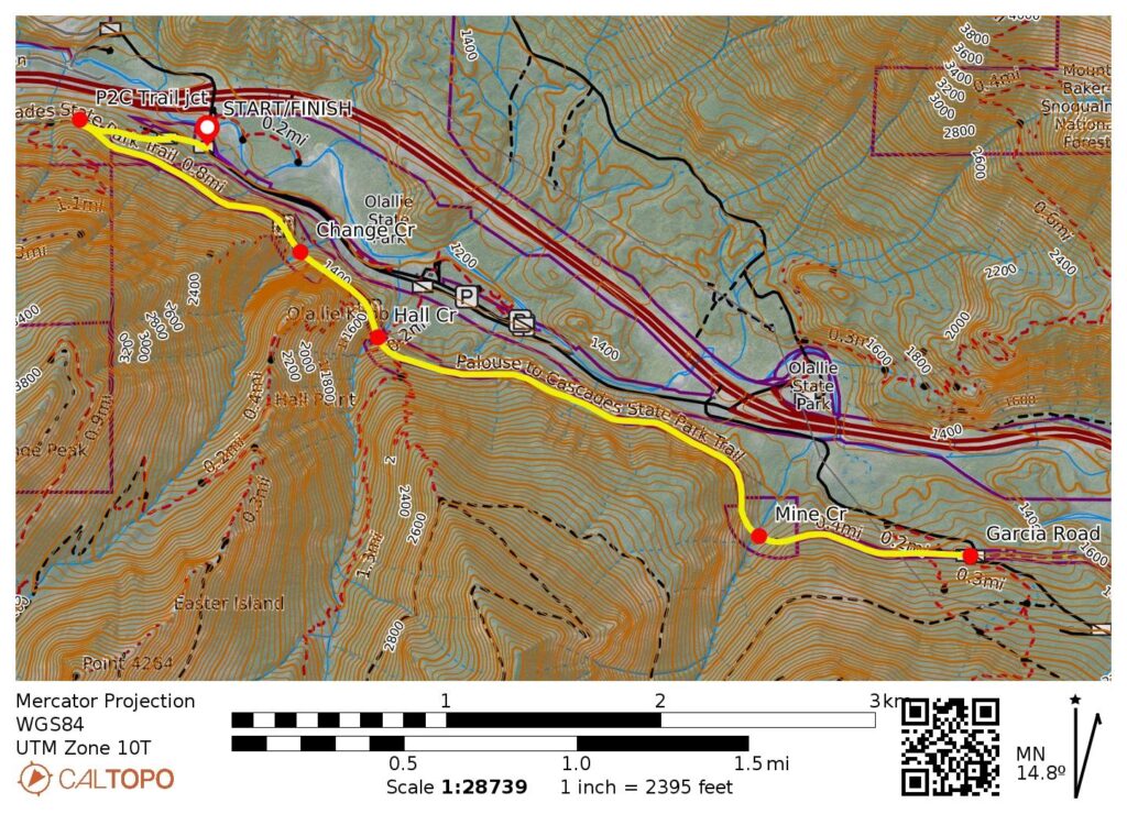
Way Points: Palouse-to-Cascades Trail junction & Change Creek Trestle & Hall Creek Trestle & Mine Creek Trestle (snowshoe trek)
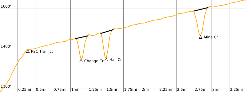
Approximate Stats (round trip): 5.6 miles traveled; 400 feet gained & lost.
Option 2: Three-Trestle Ski Tour to Garcia Road
Way Points: Palouse-to-Cascades Trail junction & Change Creek Trestle & Hall Creek Trestle & Mine Creek Trestle & Garcia Road junction (ski tour)
Approximate Stats (round trip): 7.0 miles traveled; 450 feet gained & lost.
Route Overview
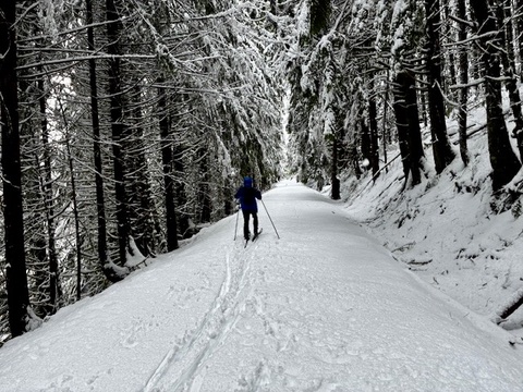
The Palouse-to-Cascades (P2C) Trail is well known to walkers, runners, and gravel bikers around North Bend, but on those occasions when the western foothills of the Cascades get blanketed with fresh snow, this former railroad grade takes on a new life as a ski touring route. Furthermore, when that blanket of fresh snow turns Interstate-90 Into a treacherous mess at Snoqualmie Pass, the trail often provides the day’s most sensible cross-country or backcountry skiing destination.
My favorite ski tour along the P2C Trail starts at or near Homestead Valley Road adjacent to Exit 38 and proceeds eastward along the trail for about 3 miles until reaching Garcia Road. The scenic highlights of this route include three marvelously high railroad trestles as well as an impressive vertical cliff frequented by ice climbers.
Although the route to Garcia Road described here is best done as a cross-country or backcountry ski tour, it is certainly possible to do it as a snowshoe trek. In this case, however, Mine Creek Trestle probably represents a logical turnaround point; the additional 1½-mile round trip to Garcia Road would be somewhat tedious on snowshoes.
Parking Comments
The easiest parking location for this trip is alongside Homestead Valley Road near the entrance of the steep access roadway leading up to Homestead Valley Trailhead. This roadway begins closely south of Interstate-90 at Exit 38. Alternatively, if the steep access roadway is plowed, or if you happen to have a very capable 4×4 rig, it is possible to start from the trailhead parking lot, thereby saving ¼ mile of skiing distance and 50 feet of elevation gain.
Full Route Description
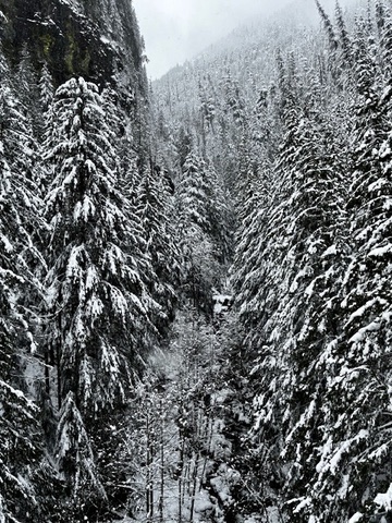
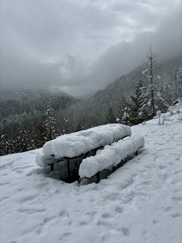
From either parking location, ski up the steep access roadway to reach the P2C Trail, then turn left and continue on this old railroad grade. After ¾ mile of flat skiing, you will cross the Change Creek Trestle—the first of three high trestles. Change Creek can be seen flowing through a narrow canyon 100 feet below. Picnic tables have been placed along the trail in this vicinity for the benefit of rock climbers and other summertime visitors.
.
.
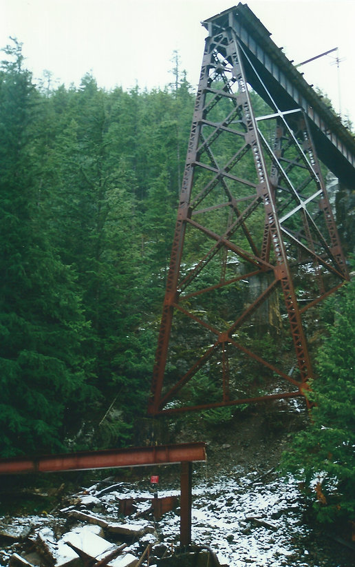
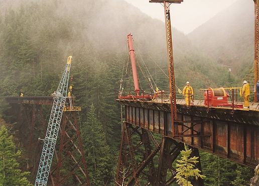
A short distance beyond, you will cross the Hall Creek Trestle (1.5 miles + 300 feet from starting point). Note that “Hall” is misspelled as “Hull” on the marker signs. The original trestle here was severely damaged in 1988 when a wintertime mudslide wiped out the middle portion, leaving a 170-foot gap. In a remarkable display of high-level crane work, Boss Construction bridged the gap with a long steel girder in January 1999. This particular trestle will always have a special place in my heart; I was fortunate to have played a small part in the engineering effort for the repair, and I observed the girder installation with my daughter on her fifth birthday.
.
.
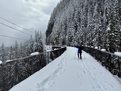
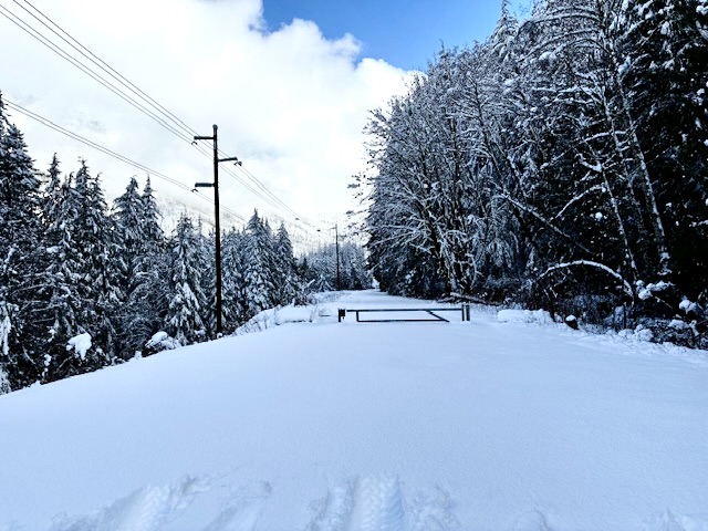
From Hall Creek, the P2C Trail makes a relatively straight traverse across a steep, wooded hillside for 1¼ miles. Interstate-90 can be heard—and occasionally seen—in the valley bottom far below. Near the end of this straight traverse, you will ski along the base of a tall, vertical cliff that typically becomes coated with ice during periods of subfreezing weather. You might see ice climbers here on frigid winter days.
.
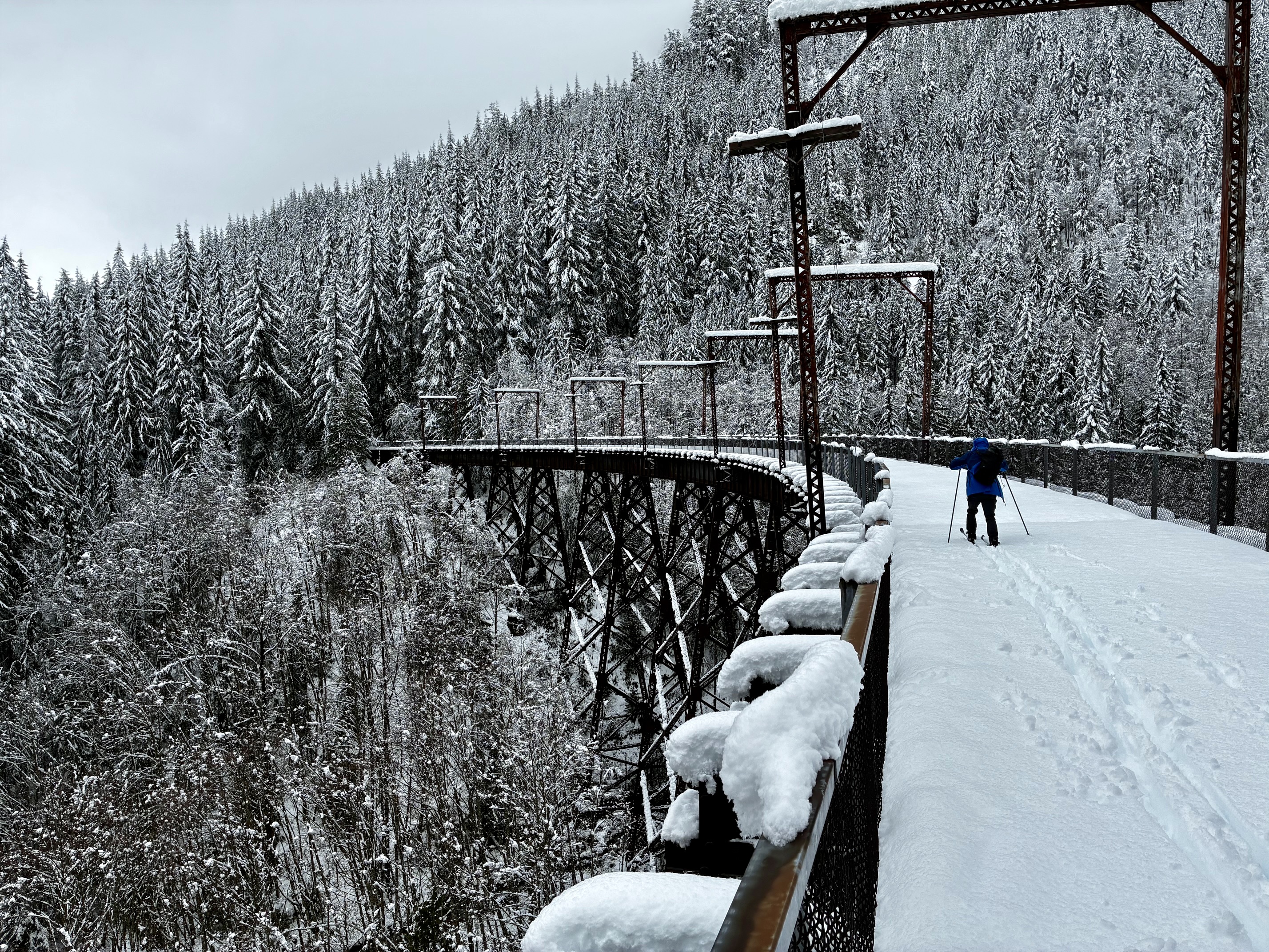
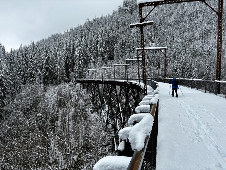
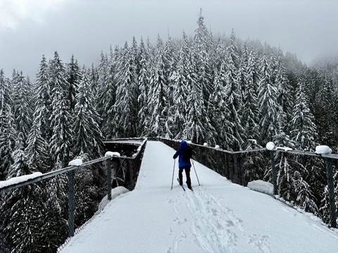
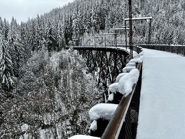
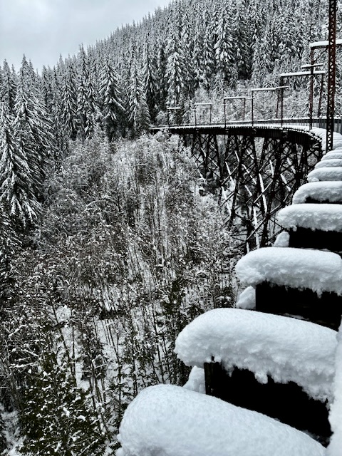
Soon after, the trail makes a sweeping right-hand curve and crosses the Mine Creek Trestle (2.8 miles + 400 feet from starting point). This is the longest and, in my opinion, most photogenic of the three high trestles. All trestles were constructed in the early 1900s by the old Chicago, Milwaukee, St. Paul and Pacific Railroad—fondly known as The Milwaukee Road—which operated freight and passenger trains between Chicago and Puget Sound for many decades. For snowshoers, Mine Creek makes a good turnaround point; you’ve now seen the best highlights of the trek.
.
.
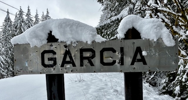
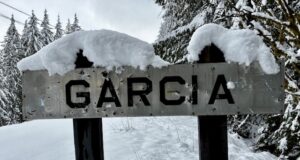
After crossing the Mine Creek Trestle, another ½ mile of skiing brings you underneath the impressive cliff of Upper Black Ice Crag and soon after to Garcia Road (3.5 miles + 450 feet from starting point). This old logging road is named after the former Garcia train stop, which is marked by a vintage railway sign. Garcia Road is a popular year-round 4×4 road, so expect to see tire tracks here.
.
Although Garcia Road represents the turnaround point for my recommended ski tour, you could certainly keep on going. From here, it is an additional 1.2 miles to Alice–Wood Viewpoint, 2.2 miles to Alice Creek Camp, 4.9 miles to Carter Creek Camp, 6.2 miles to the Hansen Creek Trestle, and a stiff 10.5 miles to the Snoqualmie Tunnel portal.
If you are turning around here, simply follow your ski tracks for 3 miles back to the access roadway junction, then descend to Homestead Valley Road. This access roadway is steep enough to be very tricky when snow conditions are crusty or rutted, so it might be prudent to remove your skis and hike down.
Route Map & Profile
…
…
Photo Gallery
Click to enlarge…